GI-EYE
GPS/Inertial mapping and georegistration system
Highlights
-
Locate/georegister objects in images
-
Absolute position accuracy < 3m at 1km
-
Relative object-to-object accuracy < .3m at 100m
-
Export/share data through Microsoft Access database
-
Built-in image enhancement capability and zoom feature
-
Accepts grayscale images in Windows BMP format
Description
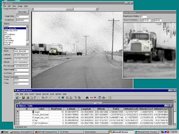
The GI-EYE system is a Global Positioning System (GPS), inertial, and digital camera sensor designed for collecting precision video data to be used for geolocation of target or feature coordinates. GI-EYE takes advantage of differential GPS to provide the precise location of each camera image by using the NAVSYS proprietary kinematic alignment algorithm to measure the precise attitude of the camera using the inertial sensor data. By recording the precise location and attitude of the video images, the extraction of feature location data is simplified and streamlined. This results in more efficient and rapid data processing, thus reducing the time required to generate high-accuracy target or feature coordinates.
End users can georegister objects for mapping and military applications, including remote, passive object targeting. MATLAB programs are called by the application to perform all algorithm calculations.
NAVSYS Corporation
14960 Woodcarver Rd
Colorado Springs, CO 80921
UNITED STATES
Tel: 719-481-4877
Fax: 719-481-4908
info@navsys.com
https://www.navsys.com
Required Products
Platforms
- Windows
Support
- Consulting
- Fax
- On-site assistance
- Telephone
- Training
Product Type
- Data Analysis Tools
Tasks
- Data Analysis and Statistics
- GPS, Mapping and Navigation
- Image Processing and Computer Vision
- Real-Time Systems
- Mapping
Related Connections Views: Data Analysis Tools, Data Analysis and Statistics, GPS, Mapping and Navigation, Image Processing and Computer Vision, Real-Time Systems