Create Interactive Basemap Picker
Interactively change the basemap of a geographic globe by adding a drop-down menu to the figure.
First, create a program file called basemapPicker.m. Within
the program file:
Create a geographic globe in a figure created using the
uifigurefunction.Specify a position for the menu. In this example, the values of
x,y,w, andhposition the menu in the upper-right corner of the figure window.Specify the basemaps to include in the menu.
Create the menu. Use a
ValueChangedFcncallback that executes when you make a selection from the menu. The callback changes the basemap using thegeobasemapfunction.Write custom code to reposition the menu when you change the size of the figure. To do this, disable automatic resizing of the menu. Then, create custom behavior by defining a
SizeChangedFcncallback. TherepositionDropdownfunction repositions the menu, so that it stays in the upper-right corner of the figure.
function basemapPicker
    uif = uifigure;
    gl = geoglobe(uif);

    x = 0.8;
    y = 0.9;
    w = 0.2;
    h = 0.1;
    uifW = uif.Position(3);
    uifH = uif.Position(4);
    pos = [x*uifW y*uifH w*uifW h*uifH];

    basemaps = ["satellite" "streets" "streets-light" "streets-dark" ...
                "landcover" "darkwater" "grayland" "bluegreen" ...
                "grayterrain" "colorterrain"];

    dd = uidropdown(uif,'Position',pos,'Items',basemaps);
    dd.ValueChangedFcn = @(src,eventdata)geobasemap(gl,src.Value);

    uif.AutoResizeChildren = 'off';
    uif.SizeChangedFcn = @(src,eventdata)repositionDropdown(dd,x,y,w,h);
end

function repositionDropdown(dd,x,y,w,h)
    fig = dd.Parent;
    uifW = fig.Position(3);
    uifH = fig.Position(4);
    dd.Position = [x*uifW y*uifH w*uifW h*uifH];
end
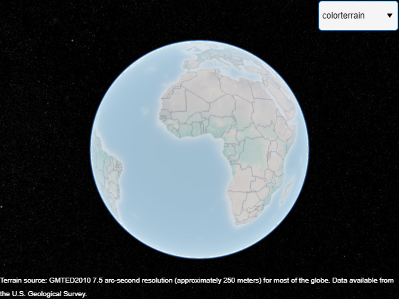
Run the program file. Change the basemap to 'colorterrain'
using the drop-down menu.
See Also
geoglobe | geobasemap | uidropdown