hereHDLMReader
HERE HD Live Map reader
Description
Use a hereHDLMReader object to read high-definition map data for
selected map tiles from the HERE HD Live Map 1
(HERE HDLM) web service, provided by HERE Technologies. HERE HDLM data provides
highly detailed and accurate information about the vehicle environment, such as road and lane
topology, and is suitable for developing automated driving applications.
You can select specific map tiles from which to read data or select map tiles based on the
coordinates of a driving route. To read map data for tiles, use the read function
and specify the reader as an input argument. For more details, see Read and Visualize HERE HD Live Map Data.
Note
Use of the hereHDLMReader object requires valid HERE HDLM credentials. If
you have not previously set up credentials, a dialog box prompts you to enter them. Enter
the Access Key ID and Access Key Secret that you
obtained from HERE Technologies, and click OK.
Creation
Syntax
Description
reader = hereHDLMReader(tileID)TileIDs property of
the HERE HDLM reader.
reader = hereHDLMReader(___,Name,Value)Configuration, WriteLocation, and CoordinateFormat properties using one or more name-value pairs. For example,
hereHDLMReader(tileID,'Configuration',config) creates a reader that
is configured to read map tile data from a specific HERE HDLM production catalog or
catalog version, where config is a hereHDLMConfiguration object.
Input Arguments
Properties
Examples
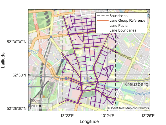
Use the HERE HD Live Map (HERE HDLM) service to read the lane topology data of a driving route and its surrounding area. Plot this data, and then stream the route on a geographic player.
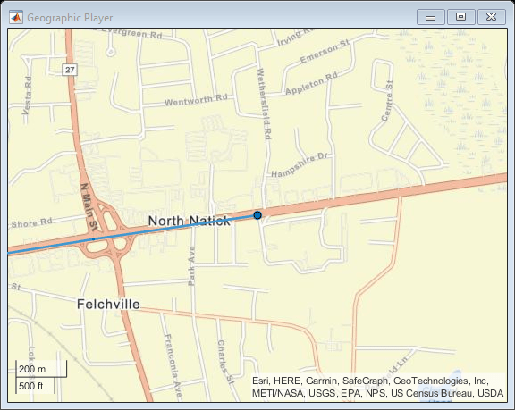
Load the latitude and longitude coordinates of a driving route in Natick, Massachusetts, USA.
route = load('geoSequenceNatickMA.mat');
lat = route.latitude;
lon = route.longitude;
Stream the coordinates on a geographic player.
player = geoplayer(lat(1),lon(1),'HistoryDepth',5);
plotRoute(player,lat,lon)

for idx = 1:length(lat)
    plotPosition(player,lat(idx),lon(idx))
end
Create a HERE HDLM reader from the route coordinates. If you have not previously set up HERE HDLM credentials, a dialog box prompts you to enter them. The reader contains map data for the two map tiles that the route crosses.
reader = hereHDLMReader(lat,lon);
Read lane topology data from the LaneTopology layer of the map tiles. Plot the lane topology.
laneTopology = read(reader,'LaneTopology');
plot(laneTopology)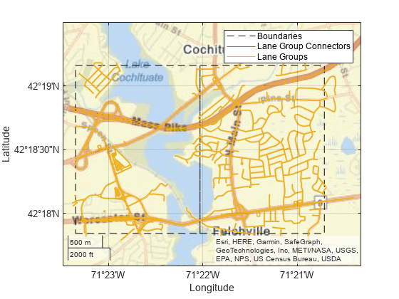
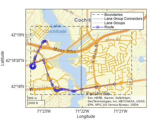
Overlay the route data on the plot.
hold on
geoplot(lat,lon,'bo-','DisplayName','Route');
hold off
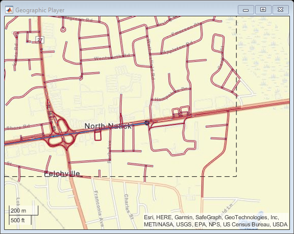
Overlay the lane topology data on the geographic player. Stream the route again.
plot(laneTopology,'Axes',player.Axes)
for idx = 1:length(lat)
    plotPosition(player,lat(idx),lon(idx))
end
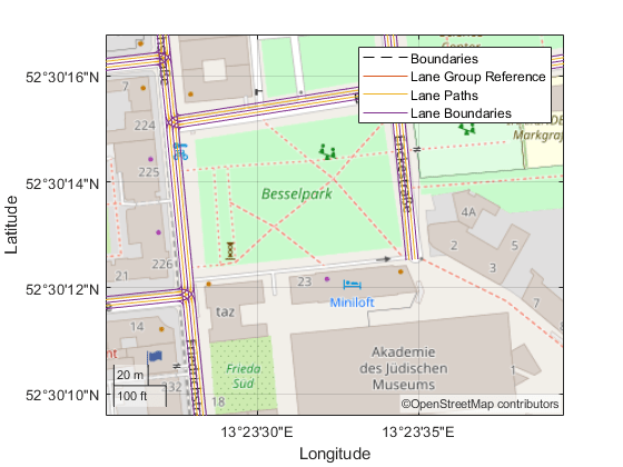
Use the HERE HD Live Map (HERE HDLM) web service to read 3-D lane geometry data from a map tile. Then, plot the 2-D part of the data on an OpenStreetMap® basemap.
Create a HERE HDLM reader for a map tile ID representing an area of Berlin, Germany. If you have not previously set up HERE HDLM credentials, a dialog box prompts you to enter them.
tileID = uint32(377894435);
reader = hereHDLMReader(tileID);
Add the OpenStreetMap basemap to the list of basemaps available for use with the HERE HDLM service. After you add the basemap, you do not need to add it again in future sessions.
name = 'openstreetmap';
url = 'https://a.tile.openstreetmap.org/${z}/${x}/${y}.png';
copyright = char(uint8(169));
attribution = copyright + "OpenStreetMap contributors";
addCustomBasemap(name,url,'Attribution',attribution)
Read 3-D lane geometry data from the LaneGeometryPolyline layer of the map tile. Plot the 2-D part of the lane geometry on the openstreetmap basemap.
laneGeometryPolyline = read(reader,'LaneGeometryPolyline');
gx = plot(laneGeometryPolyline);
geobasemap(gx,'openstreetmap')
Zoom in on the central coordinate of the map tile.
latcenter = laneGeometryPolyline.TileCenterHere3dCoordinate.Here2dCoordinate(1);
loncenter = laneGeometryPolyline.TileCenterHere3dCoordinate.Here2dCoordinate(2);

offset = 0.001;
latlim = [latcenter-offset,latcenter+offset];
lonlim = [loncenter-offset,loncenter+offset];

geolimits(latlim,lonlim)
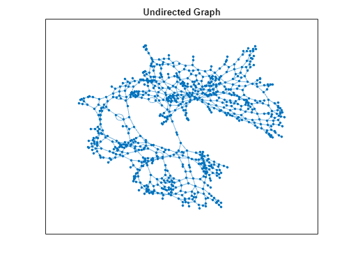
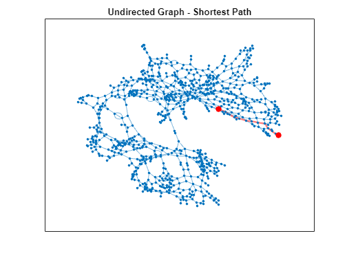
Use the HERE HD Live Map (HERE HDLM) web service to read the topology geometry data from a map tile. Use this data to find the shortest path between two nodes within the map tile.
Define a HERE tile ID for an area of Stockholm, Sweden.
tileID = uint32(378373553);
Create a HERE HDLM reader for the tile ID. Configure the reader to search for the tile in only the Western Europe catalog. If you have not previously set up HERE HDLM credentials, a dialog box prompts you to enter them. The reader contains map data for the specified map tile.
config = hereHDLMConfiguration("hrn:here:data::olp-here-had:here-hdlm-protobuf-weu-2");
reader = hereHDLMReader(tileID,Configuration=config);
Read the link definitions from the TopologyGeometry layer of the map tile. The returned layer object contains the specified LinksStartingInTile field and the required map tile fields, such as the tile ID. The other fields are empty. Your map data and catalog version might differ from the ones shown here.
topology = read(reader,TopologyGeometry="LinksStartingInTile")topology =
TopologyGeometry with properties:
Data:
HereTileId: 378373553
IntersectingLinkRefs: []
LinksStartingInTile: [1269×1 struct]
NodesInTile: []
TileCenterHere2dCoordinate: [59.3372 18.0505]
Metadata:
Catalog: 'hrn:here:data::olp-here-had:here-hdlm-protobuf-weu-2'
CatalogVersion: 21501
Use plot to visualize TopologyGeometry data.
Find the start and end nodes for each link in the LinksStartingInTile field.
startNodes = [topology.LinksStartingInTile.StartNodeId];
endNodesRef = [topology.LinksStartingInTile.EndNodeRef];
endNodes = [endNodesRef.NodeId];
Find the length of each link in meters.
linkLengths = [topology.LinksStartingInTile.LinkLengthMeters];
Create an undirected graph for the links in the map tile.
G = graph(string(startNodes),string(endNodes),double(linkLengths));
H = plot(G,Layout="force");
title("Undirected Graph")
Specify a start and end node to find the shortest path between them. Use the first and last node in the graph as the start and end nodes, respectively. Overlay the nodes on the graph.
startNode = G.Nodes.Name(1);
endNode = G.Nodes.Name(end);

highlight(H,[startNode endNode],NodeColor="red",MarkerSize=6)
title("Undirected Graph - Start and End Nodes")
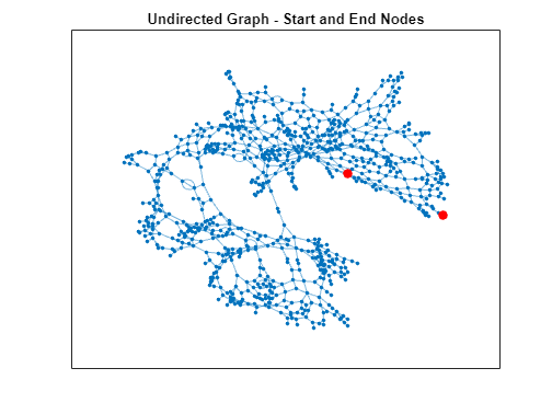
Find the shortest path between the two nodes. Plot the path.
path = shortestpath(G,startNode,endNode);
highlight(H,path,EdgeColor="red",LineWidth=2);
title("Undirected Graph - Shortest Path")
Limitations
The HERE HDLM web service determines the geographic coverage of the map data. Map data is not available for all locations.
Tips
To speed up the performance of the reader, when creating the reader, specify a
hereHDLMConfigurationobject for theConfigurationproperty. This object configures the reader to search for the selected map tiles only a specific HERE HD Live Map production catalog. If you do not specify a configuration object when you create the reader, the reader searches for the map tiles across all catalogs.To save HERE HDLM credentials between MATLAB sessions, select the corresponding option in the HERE HD Live Map Credentials dialog box. To manage HERE HDLM credentials, use the
hereHDLMCredentialsfunction.
Version History
Introduced in R2019a
See Also
hereHDLMConfiguration | hereHDLMCredentials | geoplot | geoplayer
1 You need to enter into a separate agreement with HERE in order to gain access to the HDLM services and to get the required credentials (access_key_id and access_key_secret) for using the HERE Service.