Main Content

geopeaks

Generate synthetic data set on sphere

Description

Z = geopeaks(lat,lon) evaluates a "peaks-like" function at specific latitudes and longitudes on the surface of a sphere, returning the synthetic data set Z. The function is continuous and smooth at all points, including the poles. Reminiscent of the MATLAB peaks function, geopeaks undulates gently between values of -10 and 8, with about a half dozen local extrema.

example

Z = geopeaks(R) evaluates the geopeaks function at cell centers or sample posting points defined by a geographic raster reference object, R.

example

Z = geopeaks(___,spheroid) evaluates the function on a specific spheroid. The choice of spheroid makes very little difference. This option exists mainly to support formal testing. If you do not specify spheroid and the GeographicCRS property of R is not empty, then geopeaks uses the spheroid contained in the Spheroid property of the geocrs object in the GeographicCRS property of R.
example

Examples

collapse all

Define latitude and longitude values along meridian that includes Paris, France.

lon = dms2degrees([2 21 3]);
lat = -90:0.5:90;

Generate a data set, specifying a spheroid.

z = geopeaks(lat, lon, wgs84Ellipsoid);

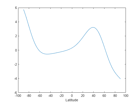
Display the profile.

figure
plot(lat,z)
xlabel('Latitude')

Figure contains an axes object. The axes object with xlabel Latitude contains an object of type line.

Create a raster reference object for a 181-by-361 grid of postings.

latlim = [-90 90];
lonlim = [-180 180];
sampleSpacing = 1;
R = georefpostings(latlim,lonlim,sampleSpacing,sampleSpacing)
R = 
  GeographicPostingsReference with properties:

              LatitudeLimits: [-90 90]
             LongitudeLimits: [-180 180]
                  RasterSize: [181 361]
        RasterInterpretation: 'postings'
            ColumnsStartFrom: 'south'
               RowsStartFrom: 'west'
     SampleSpacingInLatitude: 1
    SampleSpacingInLongitude: 1
      RasterExtentInLatitude: 180
     RasterExtentInLongitude: 360
            XIntrinsicLimits: [1 361]
            YIntrinsicLimits: [1 181]
        CoordinateSystemType: 'geographic'
               GeographicCRS: []
                   AngleUnit: 'degree'


Generate a data set.

Z = geopeaks(R);

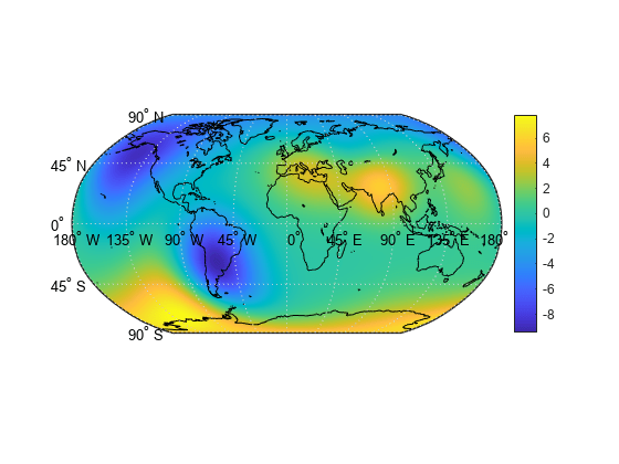
Display the resultant data set on a map.

figure
worldmap world
geoshow(Z,R,'DisplayType','surface','CData',Z,'ZData',zeros(size(Z)))
load coastlines
geoshow(coastlat,coastlon,'Color','k')
colorbar

Figure contains an axes object. The hidden axes object contains 19 objects of type patch, surface, line, text.

Input Arguments

collapse all

Geodetic latitude of one or more points, specified as a scalar value, vector, or matrix. Values must be in degrees.

The lat input argument must match the lon input argument in size unless either value is scalar (in which case it will expand in size to match the other), or lat is a column vector and lon is a row vector (they will expand to form a plaid latitude-longitude mesh).

Example: lat = -90:0.5:90

Data Types: single | double

Geodetic longitude of one or more points, specified as a scalar value, vector, or matrix. Values must be in degrees.

The lon input argument must match the lat input argument in size unless either value is scalar (in which case it will expand in size to match the other), or lon is a column vector and lat is a row vector (they will expand to form a plaid latitude-longitude mesh).

Example: lon = -180:0.5:180

Data Types: single | double

Geographic raster, specified as a GeographicCellsReference or GeographicPostingsReference object. The geographic raster stores the latitude and longitude of points.

Example: R = georefcells([0 80], [-140 60], 0.25, 0.25)

Reference spheroid, specified as a referenceEllipsoid, oblateSpheroid, or referenceSphere object.

Example: spheroid = referenceEllipsoid('GRS80')

Output Arguments

collapse all

Synthetic data set, returned as a scalar value, vector, or matrix of class single or double, depending on the class of the input. The function is evaluated at each element of lat and lon (following expansion as noted above), or at each cell center or posting point defined by R.

Version History

Introduced in R2015b

expand all

See Also