webmap
(To be removed) Open web map
The webmap function will be removed in a future release. Use
a geographic axes object instead. For information on updating your code, see Version History.
Syntax
Description
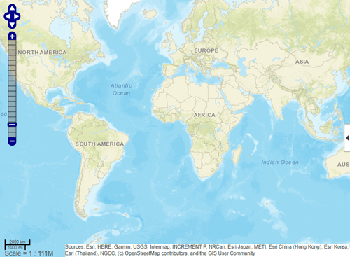
webmap opens a new web map, with its center at the
latitude, longitude point [0 0]. By default,
webmap sets the base layer to World Street Map at
the maximum spatial extent available. After the web map opens, you can
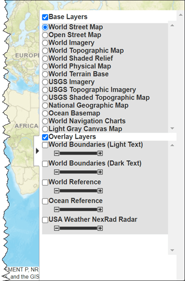
select a different base layer using the Layer Manager available on the right
side of the web map. Named base layers are tiled at discrete zoom
resolutions.
Note
The webmap function requires an Internet
connection. MathWorks® cannot guarantee the stability and accuracy of web
maps, as the servers are on the Internet and are independent
from MathWorks. Occasionally, maps may be slow to display,
display partially, or fail to display, because web map servers
can become unavailable for short periods of time.
webmap( opens a new web
map with baseLayer)baseLayer as the default base layer. See
baseLayer for a list of the available maps.
webmap( Opens a new web
map with wmsLayer)wmsLayer as the default base layer.
wmsLayer is a WMSLayer array.
The LayerTitle property of each
wmsLayer is set as an item in the Layer Manager.
webmap displays WMS layers in the "Web Mercator" map
coordinate reference system, if that projection is available for all layers
in the array. Otherwise, webmap displays the layers in
the EPSG:4326 geographic coordinate reference system. When using EPSG:4326,
webmap does not include the default base layers in
the Layer Manager since they are in a different coordinate reference system.
These projections include a geographic quadrangle bounded north/south by
parallels and east/west by meridians. Parallels map to horizontal lines.
Meridians map to vertical lines.
webmap( opens a new
web map using the custom basemap specified by the
customBasemap)addCustomBasemap function.
customBasemap is a string scalar or character
vector specifying the display name of the custom basemap, if provided, or
the basemap name.
webmap(___,'WrapAround',tf), where
tf is specified as the logical value
false or 0, opens a new web map with the display
clipped to the west at -180 degrees and to the east at +180 degrees. The
default for tf is true or 1, which
opens a map that supports continuous pan and zoom across the 180-degree
meridian. The webmap function constrains zoom to show
less than 180 degrees of longitude at a time.
wm = webmap(___)wm.
webmap( makes the web map
specified by wm)wm the current web map.
Examples
Create a web map.
webmap
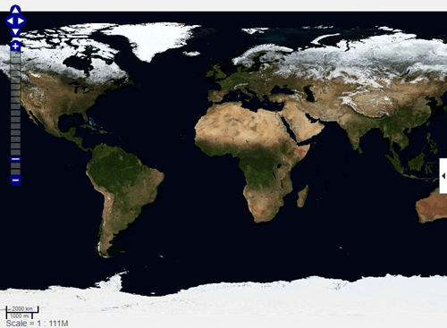
To view the list of available base layers (basemaps), open the Layer Manager by clicking the expander arrow on the right side of the map.
Search the WMS Database for WMS layers containing the string
"bluemarble". Refine the search to
include only layers from the NASA Earth Observations (NEO) WMS
server. Extract the first layer.
wmsLayer = wmsfind("bluemarble");
wmsLayer = refine(wmsLayer,"neo.gsfc.nasa.gov","SearchFields","serverurl");
wmsLayer = wmsLayer(1);
Create a web map that uses the WMS layer as the base layer.
webmap(wmsLayer)
Input Arguments
Output Arguments
Limitations
In MATLAB® Online™, if you refresh the URL, then the window containing the web map closes. In addition, if you returned a handle to the web map, then it is deleted.
More About
Tips
Particular maps may not support every available zoom level. If your map displays as white, try another zoom level. The map you are displaying might not support the zoom level you have currently selected. You can also select another base layer, which might support the specified zoom level.
Version History
Introduced in R2013bStarting in R2024a, the Ocean Basemap base layer in web map does not display
text labels. To view text labels, navigate to the Layer Manager by clicking
the expander arrow ![]() in the web map toolbar. Then, select
the Ocean Reference overlay layer.
in the web map toolbar. Then, select
the Ocean Reference overlay layer.
In previous releases, the Ocean Basemap base layer might behave unexpectedly. For example, the web map might change the zoom level or display red tiles. To use an ocean base layer in previous releases, add a custom ocean basemap from Esri. Then, create a web map that uses the custom basemap, navigate to the Layer Manager, and enable the World Boundaries (Dark Text) overlay layer. This code shows how to add a custom ocean basemap from Esri.
url = "https://services.arcgisonline.com/arcgis/rest/services/" + ...
      "Ocean/World_Ocean_Base/MapServer/tile/${z}/${y}/${x}.jpg";
sources = "Sources: Esri, GEBCO, NOAA, National Geographic," + ...
      "Garmin, HERE, Geonames.org, and other contributors";
addCustomBasemap("ocean",url,Attribution="sources")