Main Content

pointAt

Point satellite at target

Since R2021a

    Description

    Satellite Object

    pointAt(sat,coordinates) steers the satellites in the vector sat toward the geographical coordinates [latitude; longitude; altitude] specified by coordinates.

    pointAt(sat,target) steers the satellites specified by sat toward the specified target. The input target can be another satellite or ground station.

    pointAt(sat,'nadir') steers the satellites specified by the row vector sat toward the nadir direction. 'nadir' is the default pointing direction.

    pointAt(sat,attitudetable) sets the attitude of the satellite sat such that it follows the attitudes provided in attitudetable, which is a MATLAB® timetable object.

    pointAt(sat,attitudetable,Name=Value) specifies options using one or more name-value arguments in addition to the input arguments in the previous attitudetable syntax. For example, to interpret the provided attitude values as the rotation from the Geocentric Celestial Reference Frame (GCRF) to the body frame, set CoordinateFrame to inertial.

    pointAt(sat,attitudetimeseries) sets the attitudes of the satellite sat such that it follows the attitude provided in attitudetimeseries, which is a MATLAB timeseries object.

    pointAt(sat,attitudetimeseries,Name=Value) specifies options using one or more name-value arguments in addition to the input arguments in the previous attitudetimeseries syntax. For example, to interpret the provided attitude values as the rotation from the GCRF to the body frame, set CoordinateFrame to inertial.

    Gimbal Object

    pointAt(gimbal,'none') sets the gimbal angles (gimbal azimuth and gimbal elevation) of the gimbals in the vector gimbal to zero. This setting is the default.

    pointAt(gimbal,coordinates) steers the gimbals in the vector gimbal toward the geographical coordinates [latitude; longitude; altitude] specified by coordinates.

    example

    pointAt(gimbal,target) steers the gimbals in the vector gimbal toward the specified target.

    pointAt(gimbal,'nadir') steers the gimbals specified by the row vector gimbal toward the nadir direction of their parents, namely, their parent's latitude, longitude, and 0 meter altitude.

    pointAt(gimbal,steeringtable) sets the orientation of the gimbals to align with the azimuth and elevation angles provided in steeringtable, which is a MATLAB timetable object.

    pointAt(gimbal,steeringtimeseries) sets the orientation of the gimbals to align with the azimuth and elevation angles provided in steeringtimeseries, which is MATLAB timeseries object.

    Examples

    collapse all

    Create a satellite scenario object.

    startTime = datetime(2021,6,10);                      % 10 June 2021, 12:00 AM UTC
    stopTime = datetime(2021,6,11);                       % 11 June 2021, 12:00 AM UTC
    sampleTime = 60;                                      % seconds
    sc = satelliteScenario(startTime,stopTime,sampleTime);

    Add a satellite to the scenario.

    semiMajorAxis = 10000000;                             % meters
    eccentricity = 0;
    inclination = 10;                                     % degrees
    rightAscensionOfAscendingNode = 0;                    % degrees
    argumentOfPeriapsis = 0;                              % degrees
    trueAnomaly = 0;                                      % degrees
    sat = satellite(sc,semiMajorAxis,eccentricity, ...
        inclination,rightAscensionOfAscendingNode, ...
        argumentOfPeriapsis,trueAnomaly);

    Add a ground station to the scenario.

    latitude = 42.3501;                         % degrees
    longitude = -71.3504;                       % degrees
    gs = groundStation(sc,latitude,longitude);

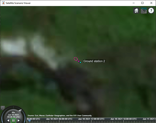
    Add a gimbal to the ground station.

    g = gimbal(gs,MountingLocation=[0; 0; -1],MountingAngles=[0; 180; 0]);

    Add a conical sensor to the gimbal.

    c = conicalSensor(g,MountingLocation=[0; 0; 0.5]);

    Point the gimbal at the satellite.

    pointAt(g,sat);

    Visualize the scenario by using the Satellite Scenario Viewer.

    v = satelliteScenarioViewer(sc);
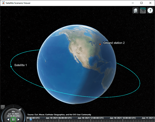
    Play the scenario.

    play(sc);

    Set the ground station as the camera target.

    camtarget(v,gs);

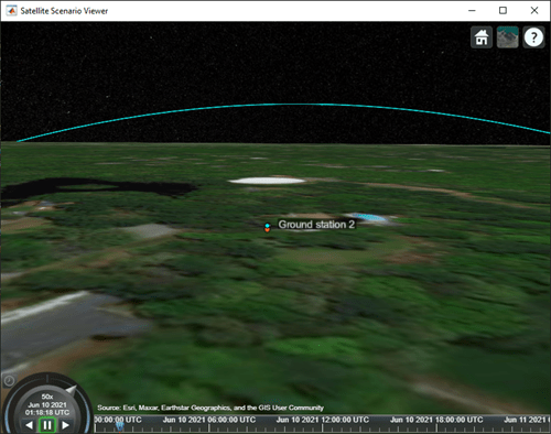
    Visualize the field of view of the conical sensor and observe the change in orientation of the conical sensor.

    fieldOfView(c);

    Input Arguments

    collapse all

    Satellite object, specified as either a scalar or a vector.

    Gimbal object, specified as either a scalar or a vector.

    Geographical coordinates of the satellite or gimbal target, specified as a three-element vector or a 2-D array.

    • When the coordinates are a three-element vector, the elements of the vector correspond to the latitude, longitude, and altitude, in that order, and all satellites or gimbals are steered to point at this location.

    • When the coordinates are a 2-D array, the number of rows must equal 3 and the number of columns must equal the number of satellites in satellite or the number of gimbals in gimbal. The rows correspond to the latitude, longitude, and altitude, in that order, and each column represents the pointing coordinates of the corresponding satellite in the vector satellite or gimbal in the vector gimbal. The latitudes and longitudes are specified in degrees and the altitudes are specified in meters, which represent the height above the surface of the Earth.

    Target at which input satellite or gimbal is pointed, specified as a scalar or a vector. The input target can be another satellite or a ground station.

    • When target is a scalar, all satellites or gimbals point to the specified target.

    • When target is a vector, the length of target must equal the number of satellites in sat or the number of gimbals in gimbal. Each element in target represents the pointing target of a satellite in sat or a gimbal in gimbal.

    MATLAB timetable with exactly one monotonically increasing column of rowTimes (datetime or duration).

    • If sat contains a single satellite, the table must contain one data column of scalar-first quaternions [1-by-4] or ZYX Euler angles [1-by-3].

    • If sat is an array of satellites, each data row must contain either:

      • Multiple columns, where each column contains data for an individual satellite over time.

      • One column of 2-D data, where the length of one dimension must equal 3 or 4, depending on whether Euler angles or quaternions are used, and the remaining dimension must have length equal to the number of satellites in sat.

      • One column of 3-D data, where the length of one dimension must equal 3 or 4, depending on whether Euler angles or quaternions are used, one dimension is a singleton, and the remaining dimension must have length equal to the number of satellites in sat.

    Euler angles represent passive, intrinsic rotations in degrees, using the ZYX rotation order. If the provided rowTimes are of type duration, time values are measured relative to the current scenario StartTime property.

    The function assumes that satellite attitudes represent the transformation from the GCRF to the body frame, unless you specify a CoordinateFrame name-value argument. For scenario timesteps outside of the time range of attitudetable, the function uses nadir by default, unless you specify an ExtrapolationMethod name-value argument.

    MATLAB timeseries containing scalar-first quaternions or ZYX Euler angles.

    • If the Data property of timeseries has two dimensions, the length of one dimension must equal 3 or 4, depending on whether Euler angles or quaternions are used, and the other dimension must align with the orientation of the time vector.

    • If sat is an array of satellites, the Data property of timeseries must have three dimensions where the length of one dimension must equal 3 or 4, depending on whether Euler angles or quaternions are used, either the first or the last dimension must align with the orientation of the time vector, and the remaining dimension must align with the number of satellites in sat.

    Euler angles represent passive, intrinsic rotations in degrees, using the ZYX rotation order. When timeseries.TimeInfo.StartDate is empty, time values are measured relative to the current scenario StartTime property.

    The function assumes that satellite attitudes represent the transformation from the Geocentric Celestial Reference Frame (GCRF) to the body frame, unless you specify a CoordinateFrame name-value argument. For scenario timesteps outside of the time range of attitudetable, the function uses nadir by default, unless you specify an ExtrapolationMethod name-value argument.

    MATLAB timetable with exactly one monotonically increasing column of rowTimes (datetime or duration).

    • If gimbal contains a single gimbal, the table must contain one data column of azimuth and elevation angles in degrees [1-by-2].

    • If gimbal is an array of gimbals, each data row must contain either:

      • Multiple columns, where each column contains data for an individual gimbal over time.

      • One column of 2-D data, where the length of one dimension must equal 2 and the remaining dimension must have length equal to the number of gimbals in gimbal.

      • One column of 3-D data, where the length of one dimension must equal 2, one dimension is a singleton, and the remaining dimension must have length equal to the number of gimbals in gimbal.

    Specify the azimuth and elevation angles in degrees. If the provided rowTimes are of type duration, time values are measured relative to the current scenario StartTime property.

    MATLAB timeseries timeseries containing azimuth and elevation in degrees [1-by-2].

    • If the Data property of timeseries has two dimensions, the length of one dimension must equal 2 and the other dimension must align with the orientation of the time vector.

    • If gimbal is an array of gimbals, the Data property of timeseries must have three dimensions where:

      • The length of one dimension must equal 2.

      • Either the first or the last dimension must align with the orientation of the time vector.

      • The remaining dimension must align with the number of gimbals in gimbal.

    When timeseries.TimeInfo.StartDate is empty, time values are measured relative to the current scenario StartTime property.

    Name-Value Arguments

    Specify optional pairs of arguments as Name1=Value1,...,NameN=ValueN, where Name is the argument name and Value is the corresponding value. Name-value arguments must appear after other arguments, but the order of the pairs does not matter.

    Before R2021a, use commas to separate each name and value, and enclose Name in quotes.

    Example: pointAt(sat,attTT,CoordinateFrame="inertial") interprets the provided attitude values as the rotation from the Geocentric Celestial Reference Frame (GCRF) to the body frame.

    Coordinate frame of custom attitude inputs, specified as one of these options.

    • inertial — Interprets the provided attitude values as the rotation from the GCRF to the body frame.

    • ecef — Interprets the provided attitude values as the rotation from the Earth-Centered-Earth-Fixed (ECEF) frame to the body frame.

    • ned — Interprets the provided attitude values as the rotation from the North-East-Down (NED) frame to the body frame.

    Data Types: char | string

    Default behavior for attitude, specified as:

    • nadir — Sets the attitude of the satellite sat such that the yaw axis points in the nadir direction.

    • fixed — Keeps the attitude constant with respect to the GCRF at the closest time value for which data is provided in the custom attitude data.

    The scenario uses this setting for scenario time steps that lie outside the provided custom attitude time range. If you do not provide ExtrapolationMethod, the function returns a warning when the scenario time is out of range of the custom attitude time range.

    Data Types: char | string

    Format of attitude data provided, specified as one of these options.

    • quaternion — Interprets the provided attitude values as scalar-first quaternions. Quaternions represent passive rotations from CoordinateFrame to the body frame.

    • euler — Interprets the provided attitude values as Euler angles, in degrees. Euler angles represent passive, intrinsic rotations from CoordinateFrame to the body frame using the ZYX rotation order and are provided in that order.

    Data Types: char | string

    Note

    When the AutoSimulate property of the satellite scenario is false, you can call the pointAt function as long as the SimulationStatus is NotStarted or InProgress.

    Version History

    Introduced in R2021a